
Cabot Shores: Malpeque Harbour Development
Location: Malpeque Bay, PE
Client: Public Services and Procurement Canada (PSPC)
Timeframe: 2019 (ongoing)
Key Personnel: Riley Guest
Project Description
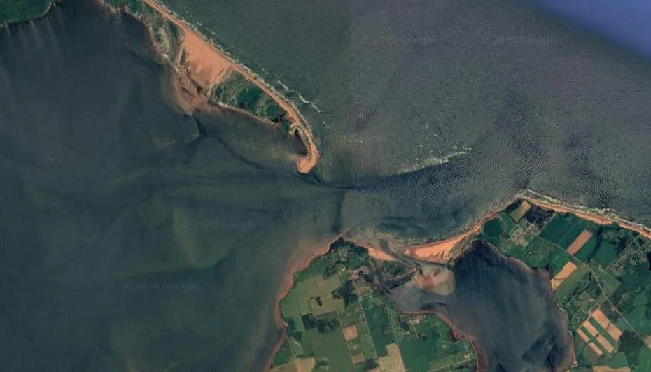
Malpeque Cove Harbour (Malpeque Cove) in Prince Edward Island is a critical area for lobster and crab fisheries and mussel and oyster aquaculture. Many businesses involving these industries work directly out of the Malpeque Bay, March Water, and Darnley Basin areas. Operations such as these are significant contributors to the PEI economy.
The Darnley Basin is a tidal inlet where the approach channel (the Darnley Channel) is natural and without breakwaters or jetties. Channels are created naturally and maintained by ambient hydrodynamic conditions such as tidal flow, river discharge, and waves. Susceptible to infilling, regular dredging of the Darnley Channel has been a necessary component of the DFO-SCH program to ensure uninterrupted access to Malpeque Cove and its associated infrastructure.
As the navigational channel used by fishers to access Malpeque Cove, the Darnley Channel had been dangerous for boat passage for many years. Fishers have had many issues attempting to navigate it, with damage to boats occurring on a regular basis. Lobster fishing and aquaculture vessels have struggled daily to access the harbour. As a result, attempts are made to enter only at high tides, with reduced loadings, or vessels sail to alternate ports altogether.

Harbourside’s Role
Economic Impact Study and New Wharf Design for Malpeque Harbour Authority
In 2019, a steering committee was formed to develop a long-term solution. The committee engaged Harbourside Engineering Consulting and MRSB Consulting Services Inc. to conduct an Economic Impact Study and New Wharf Design for Malpeque Harbour Authority.
The scope of the study was specifically narrowed to assess the cost-benefit analysis of the construction of a new facility versus maintaining the existing facility at Malpeque Cove. The study needed to consider functional and technical parameters, capital costs, long term maintenance costs, impacts to stakeholders as well as regional economic impacts.
The project team reviewed two locations for a new harbour. The conceptual design for the new harbour (Cabot Shores Harbour) is the result of preliminary design efforts and experience with similar harbours in the Atlantic region. The construction of a new harbour will be a significant undertaking in terms of estimated capital investment, construction and non-construction activities. The project team identified a construction phasing schedule spanning a four-year period commencing in early 2023 with completion in the summer of 2027.
The current concept for Cabot Shores Harbour was developed from the planning process and ensuing six layout iterations. Integral to this process was a review by Harbourside of existing similar coastline harbour facilities on PEI. Harbourside’s own historical background with these and similar locations, also played a critical role. Furthermore, Harbourside is engaged in ongoing consultative collaboration with user representatives.
Overall, the proposed Cabot Shores Harbour project is a significant investigation, design, and construction undertaking. A breakdown of different phases for this project are outlined below.
Phase 1: Creating landside access (rough grade road construction), high voltage power supply and power service building construction.
Phase 2: Construction of work surfaces to create access for required breakwater constructions and containment areas for dredged material deposition. These accesses have been configured to create ready work surfaces for rigid and floating berthage structures that will follow. These will also permit future parking.
Phase 3: Berthage wharf construction, including both floating and rigid structures and a vessel launch/retrieval slipway facility. Dredging efforts to create the proposed harbour basin are required and would be scheduled to suit rigid wharf construction.
Phase 4: Completion of power supply and water distribution, as well as post-construction final grading and paving.
Harbour & Structure Design
The proposed harbour development is to include:
Dredging of the newly formed harbour basin to elevation -2 m Chart Datum (CD)
Construction of two rubble mound breakwaters
Construction of marginal wharves on the north and east sides of the harbour basin
Construction of boat launch ramps on the east side of the harbour basin
Installation of floating docks along the south side of the harbour basin
Regrading of upland areas for parking, storage and to provide site drainage.
Construction of an approximately 950 m long access roadway connecting the site to Route 20.
The selected rigid structure is an anchored bulkhead type wall constructed of driven steel H-piling with precast concrete lagging panels installed between piles that act as a smooth berthing face. This is identical construction to most of the current structures at Malpeque Cove. The proposed floating structures (as shown on included layouts) are robust timber units in use locally by DFO-SCH since 1986 and are very familiar to local suppliers, installers, and harbour users. These wharf structures are very economical to construct, and life-cycle maintenance issues tend to be readily apparent. This allows for comparatively simple interventions in the future.
The current conceptual layout is also very accommodating to the future expansion of floating facilities for a variety of berthage needs. These uses span industrial, recreational or tourism usage. The proposed harbour basin has approximately four times the usable water lot area of the current facility at Malpeque Cove.
Geotechnical Engineering
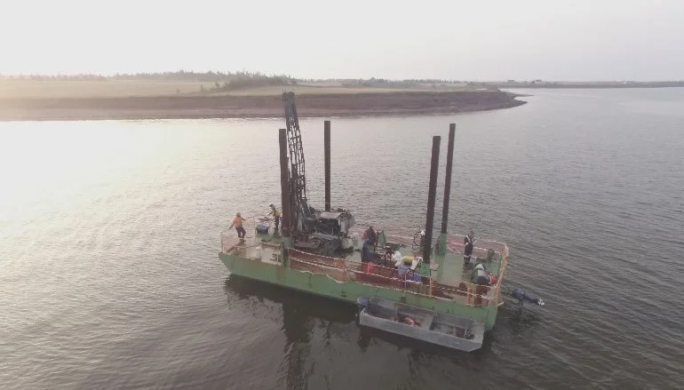
Harbourside completed a geotechnical assessment of the site and provided geotechnical design parameters and recommendations to support the concept design. The geotechnical field investigation consisted of fifteen marine boreholes, six marine dynamic cone penetration tests (DCPTs), and eleven land-based boreholes along the shoreline.
Geotechnical parameters and recommendations included comments on material dredgeability; settlement estimates; stability analyses for rubble mound breakwaters; driveability and design resistances for driven and/or socketed piles; options for marginal wharf construction; subgrade stiffness for boat ramps; effective angle of internal friction; effective cohesion; undrained shear strength; unit weights; earth pressures (active, passive, and at-rest); interface-friction factors; and seismic site classification. The investigation measured properties of the surficial soft sediments. Proper estimation of the strength and settlement properties of these materials will be critical for efficient and cost-effective design.
Samples of the soil and bedrock were recovered from the test locations, classified in the field, and taken to Harbourside’s Dartmouth, NS geotechnical laboratory for final classification and testing.
Unique Challenges
Barge work, and in water work can make for particularly challenging conditions. Work is dependent on both the tides, and weather conditions. Thorough planning is required to mitigate these factors. In addition, the geotechnical investigation portion of this project was delayed. This necessitated a readjustment of timelines.
Social Impact
The newly Malpeque Cove represents an important safety improvement for both business and recreational vessels. Upon completion, the new Cabot Shores Harbour design will help boost the local economy, increase efficiency, and make life easier for local fishing boats and leisure craft alike. Small craft harbours such as these are the life blood of the Atlantic provinces. Modernizing these ensures that local communities can remain strong, continue to prosper, and grow.